This post contains Amazon affiliate links. If you buy through them I earn a small commission at no cost to you. Everything mentioned is kit I bought myself and have used. Nobody has paid for a word of this.
At quarter past three in the morning I had a ship tracking website open, trying to work out what a bulk carrier called something I could not pronounce was doing sitting still off Anglesey.
I had counted four of them from the coast path that afternoon. Big ones, low in the water, motionless on a flat sea with nothing obviously wrong. I had assumed they were broken down, or queuing for something, or possibly abandoned. The answer turned out to be more interesting than any of those, and I will come to it.
This is the Moelfre to Lligwy coastal walk, done from Nant Bychan Farm on a grey Tuesday in August with Suzy, two small dogs and a pair of sandals.
The short version, if you just want the facts
Distance: 5.28 miles out and back from Nant Bychan Farm, or a little over four if you start from the Moelfre car park by the ice cream shop. Ascent: almost none. Time: we were out three hours and forty five minutes, of which only two hours and ten was walking. Budget three to four hours if you are stopping to eat.
Parking: Moelfre village car park at the start, or the Lligwy beach car park at the far end, so it works in either direction. I did not check the Lligwy tariff and will not guess at it.
Surface: coast path, farm track, village lane and flagstone, with gates rather than stiles on the sections we walked. The village walks board states that the stretch from the Seawatch centre out towards the Swnt is suitable for wheelchairs and pushchairs, which reaches the lifeboat station, the Royal Charter memorial, the Dic Evans statue and the island view without doing the full five miles.
Dogs: on leads throughout. It is a cliff path with drops, it runs through a village, and there is livestock fencing on the field sections, so there is no off lead space anywhere on this route. There are bins in the village. Food: Ann’s Pantry and the ice cream shop in Moelfre, and a cafe at the Lligwy end that does very good pasties and beer but is genuinely slow to serve.
The walk in real numbers
My Garmin Fenix 8 says 8.49 kilometres, which is 5.28 miles. It is an out and back rather than a loop, and the furthest point from the start is only about 1.4 miles away in a straight line. You walk the same coast twice, in opposite directions, with the light on the other side of you.
Here is the number that actually matters. We were out for three hours and forty five minutes. Of that, two hours and ten minutes was walking. The other ninety six minutes we were standing still, or sitting down, or queuing.
If you read five and a quarter miles and budget two hours, you will be wrong, and it will not be the terrain that does it. There is almost no climbing on this route. It is the stopping.
You can trim it by parking at Moelfre, by the ice cream shop above the beach, and walking to Lligwy and back from there. The campsite sits about half a mile short of the village, so that saves you roughly a mile over the round trip and loses you nothing worth having.
The whole track is on Komoot if you would rather follow it on a phone than read directions: the Moelfre to Lligwy walk as I actually walked it.

Out of the farm gate and onto the path
We are staying at Nant Bychan Farm, which I have written about before and still rate as my favourite site on the island. You leave the site along the farm’s single track lane, and a short way down there is a kissing gate on the right. Through that and you are on the coast path.

The path is new gravel here, sharp and pale, the sort that has been laid within the last year or two. It runs between a wire fence and a hedge and then simply arrives at the sea, with the water filling the whole gap ahead of you and a chimney pot off to the right.
The waymarkers are the Isle of Anglesey Coastal Path roundel, a yellow arrow on navy with a tern in the middle, sitting under the Wales Coast Path shell. Once you have seen one you will spot them everywhere, on gateposts and fence stakes all the way round.

In the third week of August the hedges either side are heavy with brambles, most of them still red and hard, a few gone black and ready. We ate as we walked, which is one of the small pleasures of doing this walk in late summer rather than June.
The nettle thing, and why dock leaves are useless
Where there are brambles at shin height there are nettles, and I got done twice reaching for blackberries.
Everybody in Britain grows up being handed a dock leaf. It does not work, and the reason it does not work is quite specific. The story we were all told is that dock sap is alkaline and neutralises the acid in the sting. Dock sap is also acidic, so that cannot be what is happening. A nettle sting is not just formic acid anyway, it is a small cocktail including histamine and acetylcholine. Any relief you get from a dock leaf is most likely the sap evaporating and cooling the skin, plus the very real comfort of somebody doing something about it.
What I use instead is plantain. Not the banana. The flat rosette weed you have walked over your whole life, either broadleaf plantain with its oval ribbed leaves or ribwort with the narrow ones and the little brown drumstick flower. Crush a leaf until it is wet, hold it on the sting, and for me the burn goes in a few minutes rather than half an hour.
I should be straight about the evidence, because I got the plant identification wrong on a walk near Chester and had to correct it afterwards. Plantain as a sting remedy is folk knowledge, not clinical trial. It is used across Europe for exactly this and it works for me every time. It is not a licensed medicine and I am not telling you it is one. But if the choice is a dock leaf or a plantain leaf, take the plantain, and take the one growing at your feet rather than the one somebody hands you.
Down into Moelfre
About five minutes in, the village appears across the bay all at once. Grey and white terraces stacked up behind a shingle beach, boats hauled out, the old blue lifeboat house at the water’s edge. It stays in front of you for the rest of the first mile, getting slowly closer.

Then the path does something I like very much. It stops being a path and becomes somebody’s flagstones. You walk between the gable end of a white cottage and a dry stone wall with petunias growing out of an old chimney pot, past a parked car, and out into the village.

Moelfre means bald or barren hill, which is what the land behind the village looks like from a boat. It has been a settlement since long before that name, and the walks board in the village claims six thousand years of it.
Ann’s Pantry sits at the top of the slip with a gable end painted in blue seashells and fish, and a takeaway hatch doing hot drinks, cake and sandwiches. There is an ice cream shop below it in Anglesey Ice Cream turquoise, made in the village since 2016, with a neon sign in the window insisting that ice cream solves everything.

A few doors up there is a wool shop in a turquoise clapboard bay window, Gwlân Siop Helen Wool, with knitting patterns faded in the glass and a closed sign hanging behind them. It was shut when we passed and I suspect it is shut fairly often, which somehow made me like it more.

On the beach below, dinghies and kayaks are pulled up on the shingle in a row, and on a clear day you can see the Great Orme sitting out on the horizon beyond them.

The Royal Charter, and 450 people thirty yards from land
Round the headland you come to the Seawatch centre, and outside it a curved bronze plate green with age. Royal Charter. Wrecked on this coast, 26th October 1859.

She was a new kind of ship, built in 1856, a big sailing clipper with two eighty horsepower steam engines to help her along, and she had run Liverpool to Australia in under sixty days. On the twenty sixth of August 1859 she left Melbourne with over three hundred and fifty passengers and a crew of a hundred and twelve, so getting on for five hundred people aboard, along with a cargo of wool and sheepskins and gold worth several million pounds in today’s money. Fifty nine days later she was off Point Lynas, a few hours from home.
The wind got up to hurricane force that night. At half past one in the morning the port anchor cable parted, and the starboard went soon after. They cut the masts away to reduce the drag and the engines still could not hold her. She struck the rocks between Moelfre and Lligwy Bay.
She was thirty yards from land. In the dark, in that sea, thirty yards was impossible. A Maltese sailor called Joe Rogers got a line ashore, a bosun’s chair was rigged from it, and sixteen crewmen came off that way before the ship broke up. Over four hundred and fifty people died.
Charles Dickens came at Christmas, walked the same beach, and wrote it up from the account of the local rector, the Reverend Stephen Roose Hughes of Llanallgo, who with his brother spent weeks identifying the dead and writing to their families. There are memorials in Llanallgo churchyard and on the rise above the bay.
It is not the only thing that happened on this water. In 1862 a new ship called the Enrica sheltered in Moelfre Bay before slipping away to be armed and renamed. She became the CSS Alabama, and spent the American Civil War burning Union merchant ships across two oceans.
Dic Evans, and the lifeboat that is still there
Above the Seawatch there is a bronze of a man at a ship’s wheel in oilskins, looking out to sea and not enjoying what he can see.

That is Richard Evans, Dic Evans, coxswain at Moelfre. Fifty years in the lifeboat service. Two RNLI Gold Medals, which almost nobody gets one of.
The first was the Hindlea in October 1959, almost a hundred years to the week after the Royal Charter, in the same bay, in winds recorded at a hundred and four miles an hour. The coaster was dragging her anchors towards the rocks with eight men aboard. Evans took the lifeboat alongside repeatedly while both vessels were being thrown about, and got all eight off. The second was the Greek freighter Nafsiporos in 1966.
There has been a lifeboat here since 1848, first under the Anglesey Association for the Preservation of Life from Shipwreck and then under the RNLI from 1855. It is not a museum piece. The station still runs an all weather Tamar class boat, the Kiwi, on station since 2013, and the slipway drops straight into the water at the end of the building.

Walking past a working lifeboat station just after reading about four hundred and fifty people drowning within shouting distance of the shore is a particular sort of feeling, and I would not skip it.
Ynys Moelfre, and what is living on it
Past the lifeboat station the path climbs a little and the island comes into view, low and flat and green on top.

It is called Ynys Moelfre, which simply means Moelfre Island, although locally you will hear it called Rat Island. At low tide it is about two hundred and sixty metres long and covers six and a half acres. The channel between it and the village is called Y Swnt, the Sound, and it is never more than a hundred and ninety four metres wide. At low tide it is only waist deep the whole way across, and on the biggest spring tides you can apparently walk over dry.
There is nothing built on it. Gulls, terns, gannets, fulmars and skuas use it, and there is a colony of seals. I have seen seals here more than once over the years, usually as a head in the water that you assume is a buoy until it turns and looks at you. Porpoises come through too. Those I have seen less often and never for long, a dark curve and then nothing, but they are there.
On the flat rock ledges below the path there is nearly always somebody fishing, chairs out, rods propped, the whole family sat behind. What they are catching is mostly mackerel, and dogfish when the mackerel are not playing.

Behind them, on a decent day, the whole Snowdonia skyline sits across the water. That view is the reason to do this walk in the direction we did, coming back with it in front of you rather than behind.
So why are all those ships parked out there
Here is the 3am answer.
That stretch of water is the Lynas anchorage, and it is one of the most useful bits of sea in the Irish Sea if you are a large ship with time to kill. The water is deep close inshore. The land shelters it from the prevailing south westerlies, so it stays calm when the open sea is not. It sits right by the pilot boarding station off Point Lynas, where the Liverpool pilots come aboard. And from there it is a straight run to the Mersey with no tidal gate to wait for.
So ships sit there waiting for a pilot, or for a berth to come free, or for the wind to drop, because when it blows hard enough the cranes at Liverpool stop working and there is no point arriving. Sometimes they are simply early.
The bit I had not thought about is the money. Dropping an anchor costs nothing. Sitting in a port costs a great deal. So if you are ahead of schedule, the economically sensible thing is to park off a Welsh village and wait, which is why locals have been watching ships do this since at least the 1980s and why on a busy week you can count more than a dozen.
Standing on the same headland where the Royal Charter came ashore, looking at four modern ships choosing to shelter in exactly that bay, is not a bad way to understand why this coast has the history it has.
The stretch to Lligwy
North of Moelfre the path turns west and the character changes. Less village, more cliff and gorse and bracken going brown at the edges. There are pebble beaches down to the left where somebody has been building cairns, dozens of them, a whole field of little stacked towers on white limestone shingle.
This coast between Lligwy and Moelfre is a Site of Special Scientific Interest for its rock formations, sandstones and conglomerate and a dark limestone, and the whole coastline has been an Area of Outstanding Natural Beauty since 1966. Anglesey has two hundred and one kilometres of it, the largest AONB in Wales. The interpretation board says the rocks are between three and four million years old, which I am fairly sure is a typo for three or four hundred million, but I liked the board too much to hold it against it.
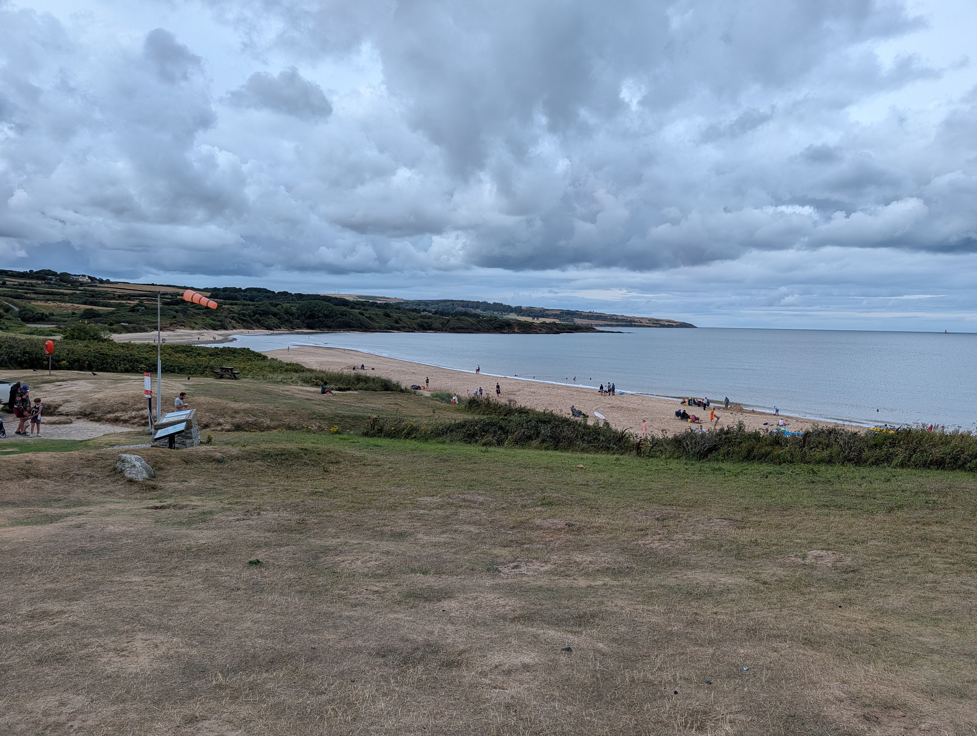
Then the land opens out and Lligwy beach appears, a proper wide arc of sand with a windsock on the rise above it and the dunes running back into the fields.

The café, and the one honest complaint I have
There is a café at the top of the Lligwy car park, a small white building with a marquee attached to it doing pizza and a bar, and Yarde Farm ice cream out front.

The food is genuinely good. Coffee, cold beer, very good sausage rolls, and cheese and onion pasties that I have thought about more than once since. If you have walked from Moelfre you have earned one and it delivers.
The service is slow. Not busy day slow. Slow. We waited around ten minutes to be served and the place was not full, with empty benches around us. If you are on a tight turnaround, or you have a small child who has decided they are hungry now, factor that in. It is a large part of where our ninety six stationary minutes went, and I would rather tell you than have you find out with a toddler at your knee.
It did not stop us. It would not stop me going back. But an honest review has to include the bit that irritated me, and that was it.
What we did not do, and probably should have
A short distance inland from Lligwy there are three things I walked straight past.
Din Lligwy is the ruin of a Romano British settlement, round stone huts inside a walled enclosure. Hen Capel Lligwy is a twelfth century chapel standing roofless in a field. And Lligwy burial chamber is a Neolithic tomb roughly six thousand years old with a capstone that is reported to weigh around twenty five tonnes.
All three are within a few minutes of the beach. We did not go, because we had two dogs, a pasty each and a walk back still to do. I am putting them here because I would have liked somebody to tell me before I got there rather than after, and because I fully intend to go and see them next time.
There is also an old fish weir at Lligwy Bay, stone foundations on the south side of the bay that show at low tide. We were there at the wrong state of the tide to see it.
Doing it with two small dogs
Cujo and Blaze both came. Blaze, the chorkie, would do this walk twice and ask what else there was.
Cujo is different. He has a heart condition, so five and a quarter miles is not on for him. What works is that he walks the first mile under his own steam, enjoying himself, and then rides the rest.
He rides in an Outward Hound PupPak front carrier, the small grey one, rated to about ten pounds. It goes on like a rucksack worn backwards, so the dog sits against your chest with his head out, and there is a clip inside that attaches to his harness so he cannot launch himself at a passing spaniel. Padded straps, mesh sides, and it has stayed comfortable over a couple of hours of walking. Of everything I have bought for these dogs it is the one that has changed what we can actually do together, and I would buy it again tomorrow.
The other thing that comes every time is a COTOP portable dog water bottle, the 350ml one. It is a bottle with a hinged trough on top, so you squeeze water into the trough, the dog drinks, and whatever is left drains back into the bottle when you close it. No bowl, no waste, one hand. Cujo has worked out exactly what it is and now barks at the bottle when he is thirsty, which is either very clever or mildly humiliating depending on who is watching.
On the dog friendliness of the route itself: the path is fully accessible to dogs the whole way, there are bins in the village, and Moelfre Community Council have put bilingual signs on the fence posts asking you to pick up. There is no dedicated off lead space anywhere on this walk. It is a cliff path with drops, it runs through a village, and there is livestock fencing along the field sections, so mine stayed on leads throughout.

What I wore, since somebody always asks
Hoka Infini Hike TC sandals again, which I reviewed here after three weeks and have now put a decent number of miles through. Five and a quarter miles on gravel, flagstones, grass and shingle on a warm day, and no rubbing and no blisters.
They are a warm weather shoe and I would not take them out in October. But on a day like this one they are the right answer, and the fact that I can walk this far in sandals and forget I am wearing them is the whole point of them.
Practical bits
The full walk from Nant Bychan Farm and back is 5.28 miles. The campsite sits about half a mile from the village, so starting instead from the Moelfre car park by the ice cream shop makes it a little over four. There is also a car park at Lligwy at the far end, so you can do it in either direction. I did not check the Lligwy tariff and I am not going to guess at it.
There is almost no climbing. The whole route is coast path, farm track, village lane and flagstone, with gates rather than stiles on the sections we walked.
Worth knowing if it matters to you: the village walks board states that the coastal path section from the Seawatch centre out towards the Swnt is suitable for wheelchairs and pushchairs. That is a short there and back rather than the full route, but it means the lifeboat station, the Royal Charter memorial, the Dic Evans statue and the island view are all reachable without doing five miles.
Allow three to four hours if you are going to stop for food, and take the plantain advice with you.
More on this stretch of coast in the campsite reviews, and the rest of the island’s sites are collected there too.
Two more with the same kind of map drawn from my own watch data. The Cefni Reservoir loop is the flat inland one we did the following day, twenty five minutes from here, with a mothballed Victorian railway still lying in the undergrowth. Bod Petryal in Clocaenog Forest is back on the mainland near Ruthin, free parking and easy graded forest track, and Cujo walked all of that one.
I’m Pete Harrison. I’m 55, I live in Buckley in North Wales, and I have a mild case of insomnia that means I spend a lot of time at 3am reading about things I saw that afternoon and did not understand. Things I Learnt at 3am is where I write honestly about what I’ve actually bought, walked, tested and lived with.
Leave a Reply