This post contains affiliate links to kit I own and paid for myself. If you buy through one I may earn a small commission at no extra cost to you. It makes no difference to what I write. The walk itself is free and I have no commercial relationship with Natural Resources Wales or anybody else mentioned here.
I was awake at three in the morning having an argument with myself, and losing.
The argument was about whether to write this at all. We had spent the afternoon somewhere I had never heard of, forty minutes from the house, and my first instinct on getting home was to say nothing to anybody. Not here. Not in the groups. Keep it. There is a particular kind of selfishness that arrives when you find somewhere quiet, and I had it badly.
I lost the argument, obviously. Here it is.
The short version, if you just want the facts
Where: a car park, a lake and a picnic site in Clocaenog Forest, on the B5105 between Clawddnewydd and Cerrigydrudion, south west of Ruthin. Grid reference SJ 036 512. Use the grid reference rather than searching the name, which can send you somewhere unhelpful. Natural Resources Wales look after it.
Parking: free and gravel, and big enough that six metres of campervan needed no manoeuvring. No overnight stays. A marker post by the picnic field carries four symbols struck through in red, for fires, tents, caravans and motorhomes, and separate signs ban BBQs. This is a day visit and it is signed as one.
Facilities: wooden picnic tables, an information board and a leaflet dispenser. No toilets, no water, no bins, and no dog bins. Whatever comes in with you goes home with you.
The trails: three, all waymarked and graded easy. Keeper’s Stroll, yellow, three quarters of a mile, about twenty minutes. The Animal Puzzle Trail, also yellow, three quarters of a mile, about thirty minutes, with a leaflet of clues for children. The Bod Petryal Trot, green, two miles of forest road, an hour and a quarter walking, and the one that takes a pushchair, a bike or a horse.
What we walked: both loops, which came to 3.27 miles with 62 metres of climbing, in an hour and a half, sixteen minutes of which we spent standing still. The climb is spread over a mile and barely registers as one.
Dogs: on leads. It is a working forest shared with cyclists and horse riders, there is no off lead field, and there is no water bowl or dog bin. There were blue green algae warnings on the lake when we visited, which matters far more for dogs than for people, so read the notices when you arrive.
Driving times, approximate: Buckley and most of Flintshire about forty minutes, Chester about fifty, Ruthin fifteen to twenty, Mold around forty five, Wrexham roughly an hour.

Where Bod Petryal is, and why you have probably driven past it
Bod Petryal is a car park, a lake and a picnic site in Clocaenog Forest, on the B5105 between Clawddnewydd and Cerrigydrudion, south west of Ruthin. The grid reference is SJ 036 512. Natural Resources Wales look after it.
Clocaenog is not small. The board in the car park describes it as the size of ten thousand rugby pitches, which is a hundred square kilometres, sitting at the southern end of Hiraethog Moor. There are half a dozen NRW car parks dotted around it and this is only one of them.
I have lived in Flintshire for years. I had no idea any of it was there.
Rough driving times. Chester is about fifty minutes. From Buckley and most of Flintshire, closer to forty. Ruthin is the nearest town of any size, fifteen to twenty minutes away over the Clwydian Hills, which is a good drive out and a better one back. Mold is around forty five minutes and Wrexham the longest at roughly an hour. Treat those as approximate.
One warning on the postcode. Searching the name can send you somewhere unhelpful. Use the grid reference or the NRW page, and once you are on the B5105 the brown signs do the rest.
The parking, which is the bit people actually want to know
The car park is free. It is gravel, it is a decent size, and it was nowhere near full on a wet Saturday. We parked the Giottivan alongside a couple of estate cars and a family unloading bikes, and nobody had to breathe in. Six metres of van is not a problem here.

Now the important part, and it is unambiguous. There are no overnight stays. There is a marker post by the picnic field carrying four symbols, all struck through in red: no fires, no tents, no caravans, no motorhomes. Underneath it says Dim aros dros nos. There is a separate red sign on the notice board saying no BBQs or fires, and a yellow one warning of extreme fire risk when the forest is dry.


So this is a day visit. Do not turn up at nine at night with the blinds down and hope for the best. It is clearly signed on Welsh Government land, and it is exactly the sort of thing that gets sites closed for everybody when it is ignored.
Facilities are minimal. Wooden picnic tables, one of them by the water. A large information board with the trail maps. A leaflet dispenser for the Animal Puzzle Trail. We saw no toilets, no water and no bins, including no dog bins.
One thing to check before you let a dog near the water
When we visited there were warning signs up about blue green algae on the lake.
This matters more for dogs than for people. Blue green algae is a bacteria rather than a true algae, it blooms in still fresh water in warm weather, and some blooms produce toxins that can make a dog seriously ill very quickly. Dogs are particularly at risk because they drink the water and then lick it off their coats afterwards. Ours did not go anywhere near it.
Blooms come and go, so the signs may well be gone by the time you read this. Look for the notices when you arrive and take them seriously if they are there. If a dog does get into suspect water, rinse it off and ring a vet rather than waiting to see.
Three waymarked trails, and the one we actually walked

The Keeper’s Stroll, yellow waymarkers, three quarters of a mile, about twenty minutes. Huge trees, the old gamekeeper’s cottage and the lake.
The Animal Puzzle Trail, also yellow, three quarters of a mile, about thirty minutes, starting on the same route. Take a leaflet from the dispenser and it gives children clues to find animals hidden in the woods.
The Bod Petryal Trot, green waymarkers, two miles or 3.3 kilometres. An hour on a horse, an hour and a quarter walking, twenty minutes on a bike. Forest road the whole way, shared with cyclists and riders, and the one that would take a pushchair.
We did not do one of them, we did a couple. There is a loop on each side of the road, the smaller one down by the lake and the bigger one climbing away to the south west, and we walked both. It came out at 3.27 miles in an hour and a half, with 62 metres of climbing. Sixteen of those ninety minutes we spent standing still. The full route is on Komoot if you want to follow it.
Two confessions about how we did it. We walked one of the loops the wrong way round, which we only worked out when the waymarkers started appearing on the backs of the posts, and at one point we took a wrong turn and had to walk back out of it. Neither mattered. The waymarking is good if you are going in the direction it expects, and if you are not, you get there anyway.


A bit of history, because the name is not decoration
Bod Petryal means rectangular dwelling. It is named after the old gamekeeper’s cottage that stands nearby, and the cottage is the surviving clue to what this place used to be.
All of this was once part of the Pool Park Estate, owned by the Bagot family. That is why there is a gamekeeper’s cottage in the middle of a conifer plantation, and why the oldest trees in Clocaenog are gathered around this particular car park rather than spread evenly through the forest. You are walking through the remains of a private estate that the twentieth century built a forest on top of.
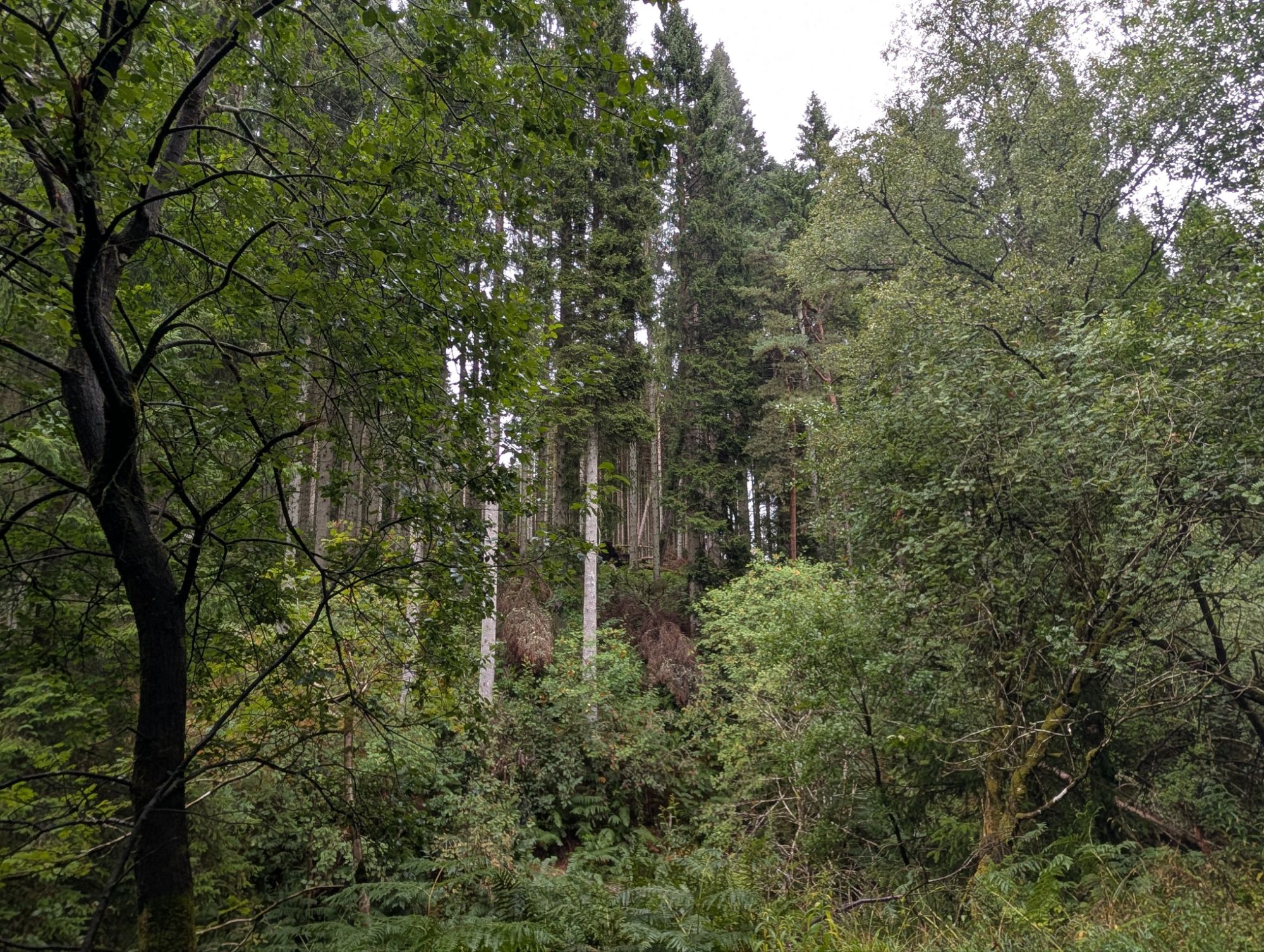
The forest itself came later. The Forestry Commission planted Clocaenog between 1930 and 1952 on open upland moorland, five thousand hectares of it, dominated by Sitka spruce. It is still a working forest. You will see stacked timber beside the tracks and the occasional block that has been felled and replanted, which is not scenery going wrong, it is the place doing its job.
Estate, then plantation, now a place people bring their dogs. Three completely different uses of the same ground inside about a century.

The wildlife, including what you will almost certainly not see
Clocaenog is one of only three focal sites for red squirrels in Wales. The other two are mid Wales and Anglesey.

The board explains something I had never come across. Sitka spruce seeds are so small that grey squirrels struggle to eat enough of them to make a living, so a big block of Sitka is quietly hostile to greys and works in the reds’ favour. That is why this forest became a refuge as greys spread across Wales, and in the 1990s it held the largest red squirrel population in the country, before Anglesey’s recovery overtook it.
Numbers here have since dwindled. Greys have pushed in, competing for food and carrying squirrelpox, a virus which does nothing to them and kills reds. There is a Magical Mammals project running, funded by the National Lottery Heritage Fund, NRW and the Clocaenog Forest Wind Farm Fund, releasing zoo born animals to boost the population.
NRW are honest about your chances. Reds range over large areas and are secretive, and you will be very lucky to see one. We were not lucky.
Black grouse live on the forest edge, the ones famous for the communal courtship display called lekking. They are rare and they are a dawn proposition on open moorland edge, not something you stumble into on a Saturday afternoon walk. Woodpeckers are the realistic one, and NRW specifically suggest listening for them while you are having your picnic by the lake.
What we actually got was rain, a lot of very wet moss, and two dogs who between them detected nothing more exotic than a pine cone. I am not disappointed by that. A forest where the rare things are genuinely hard to see is a forest where the rare things are being left alone.
The plants, since I keep stopping to look at them now

Heather stopped me first. A whole bank of it in flower where the trees thinned, pale pink and just going over, which is exactly right for the end of August. Growing up through it, bilberry, low and glossy and green.
Bracken lines most of the tracks, shoulder high in places and already showing the first orange at the tips. Rowan is everywhere along the forest road, hung with red berries, and it looks like a good year for them.

The plantation is Sitka spruce dominated, with broadleaf mixed in along the edges, and there is a large horse chestnut hanging over the car park that was already dropping conkers in August.
Two more worth a mention. Rosebay willowherb in bright pink spikes wherever trees have come out, which is precisely the ground it likes. And a large colony of round, rhubarb sized leaves along a wet ditch that I am fairly confident is butterbur, though I am hedging that, because I have been wrong about a plant on this blog before and had it corrected inside a day.

What it is actually like to walk
Wet. It rained on us for most of it, which I am not going to pretend was a hardship, because the forest was better for it.
Everything was dripping. The moss on the boulders had gone luminous. The gravel road runs between spruce so tall and so straight that you keep looking up without meaning to, and in a couple of places the trees close over the track and the light turns green.
I am fifty five years old and not given to whimsy, but there is a stretch where a narrow path leaves the forest road and climbs through the pines, and I stood there thinking about Lothlórien. It looks like somewhere a Tolkien location scout would have wept over. If you have ever wanted to walk through a landscape that feels older and larger than you are, this does it, and it does it forty minutes from a retail park.

Cujo did the whole thing
This is the part I did not expect to be writing.
Cujo is a champagne long haired chihuahua with a heart condition, and I have got used to planning walks around what he can manage. On the Anglesey coast he has done a couple of miles and then finished the day being carried, entirely unembarrassed about it.
Here he walked the lot. All 3.27 miles of it, on the lead, in the rain, at his own pace.

I think the ground is the reason. Forest road and level woodland path, no stiles, nothing steep, and the one climb spread over a mile so gently that you barely register it as a climb. A dog who runs out of puff on hills can keep going on this.
Blaze, who has no such limitations, spent the entire walk with her nose in the leaf litter.

Which brings me to the cost of all this. Both of ours are low slung, and a wet forest track at ground level is a different experience from a wet forest track at six foot two. They came back the colour of the path. Both of them had to tolerate a shower when we got home, and neither of them tolerated it well.
Bring a towel and put something down in the back. If your dog sits low, plan on washing it.
Both stayed on leads throughout. This is a working forest with horses and cyclists on the same tracks, there is no off lead field here, and there is no water bowl or dog bin either. Bring your own of both.

What I wore and carried
Nothing here was bought for this walk. It is all kit I use every week, which is the only reason it is worth mentioning.
Hoka Gaviota 6 on my feet. These are a stability road shoe rather than a boot, and on a wet forest road that is a perfectly sensible choice. Grip on wet gravel and packed earth was fine. I would not take them up anything steep and rocky in the rain, and the narrow yellow sections were soft enough that a proper boot would have been better, but for two hours of graded track they were the right call and my knees said so afterwards. Hoka Gaviota 6 on Amazon.
Garmin Fenix 8 47mm on my wrist, which is the only reason I can tell you any of the numbers in this post. I have written up the Fenix 8 properly after six months of daily use, including what happened when I needed reading glasses for the first time. It also gave me a useful lesson in reading your own data on this walk, since I forgot to stop the recording when we drove off and the raw file cheerfully added the first half mile of the B5105 to the total. Worth knowing if you ever publish your own figures. Garmin Fenix 8 on Amazon.
Hilo blood pressure band, as always. I have worn one every day for two years and it goes on walks because it goes everywhere. That is long enough to have a genuine opinion on whether a cuffless band is worth the money, and long enough to have run a proper experiment on myself with it. Hilo, direct from Hilo.
The dogs’ water bottle, which mattered more than usual here because there is no water on site and I would not have let them drink from the lake even without the algae signs. Ours is the COTOP, the type with the flip out bowl built into the lid, so one hand does the whole job while the other holds two leads. COTOP dog water bottle on Amazon.
And one thing with no link on it, because nobody needs a recommendation for poo bags. There are no bins here at all. That means whatever your dogs produce travels home with you, and in our case it travelled home in a small van that we were also sitting in, drinking coffee, for the next twenty minutes. Tie them tight, double bag them if you have any sense, and keep them somewhere that is not the footwell.
The van earned its place
The Giottiline Giottivan 60T turns a walk like this into a day rather than an errand.
We came back to it soaked, put the kettle on, and had soup and a coffee sitting in the dry watching the rain come through the chestnut tree. Ten minutes and we were warm again. No queue, no café, no driving home wet in the hope of a hot drink at the other end.
That is genuinely the whole argument for a small van in North Wales. Not touring the continent. Being able to stop somewhere like this on a filthy afternoon and stay comfortable.
So where can you actually stay overnight nearby?
Not here, as covered. And I want to be straight about the wider answer, because it is not the one van owners want.
There is no legal right to sleep overnight in a vehicle in Denbighshire. That is the council’s own position, not my interpretation. Free spots in this part of Wales are not a thing you can rely on, and the laybys and forest car parks that get passed around are exactly the ones that end up gated.
Two realistic routes instead.
Brit Stops. You buy the book or the membership, and hosts then offer free overnight parking with no obligation to buy anything, though buying something is the entire point of the arrangement working. There are hosts in the Ruthin and Corwen area, which puts you within twenty minutes of the forest. It is the closest thing to a French aire that this country manages, and it is the option I would use.
The Denbighshire aires, eventually. The council has been progressing plans for six short stay motorhome aires, including Park Street in Ruthin and Green Lane in Corwen, both within easy reach of Clocaenog, plus Llangollen, Prestatyn and two in Rhyl. These are paid rather than free, and as far as I know they were still working through planning and objections earlier this year rather than open for business. Worth checking before you count on one.
If you know of a genuinely authorised spot closer than that, tell me and I will add it.
The argument I lost at 3am
Here is the case for keeping quiet. It is quiet now. There were maybe six vehicles in that car park on a Saturday. Write it up, share it about, and the thing that makes it good gets diluted.
Here is the case against, which is the one that won. A hundred square kilometres of forest is not going to be ruined by one blog with thirteen subscribers. The people who look after it want it used, which is why they built the car park and printed the leaflets. And I have spent most of this year writing about Anglesey while a forest this good sat forty minutes from my front door, unvisited, because nobody had told me.
Somebody had to tell me. Nobody did.
So: free parking, three easy waymarked trails, a lake, picnic tables, no facilities, no overnight stays, red squirrels you will not see, and a stretch of path that made a man of fifty five think about elves.
Go on a wet day. It is better in the rain.
If you want the coastal version of this, the two Anglesey walks are the obvious contrast: Moelfre to Lligwy for the cliff path and the lifeboat history, and the Cefni Reservoir loop for another flat, dog friendly circuit round water. Both have the same kind of map as the one above. If you would rather stay inland and have a van, the drowned village under Lake Vyrnwy is the other Welsh reservoir worth the detour.
Get the next walk write-up
Every walk I publish gets the real numbers, a map drawn from my own watch data, and an honest note on whether two small dogs could actually manage it. Subscribe and I will send you the next one.
What else am I driving past? I have clearly not been paying attention to my own corner of Wales. If there is somewhere inland in Denbighshire or Flintshire you would put in the same bracket as this, tell me, because I would rather be told than find it by accident again in five years.
Pete Harrison is 55 and lives in Buckley, Flintshire. He writes about the gear, the walks and the campervan trips he has actually done, usually because he could not sleep and ended up researching them at 3am.
Leave a Reply